The map was shared on the US Trade Representative’s Office X handle and clearly demarcated the northern Union Territory of Jammu and Kashmir within Indian territory. The depiction assumes significance amid continued tensions between India and Pakistan over the region.
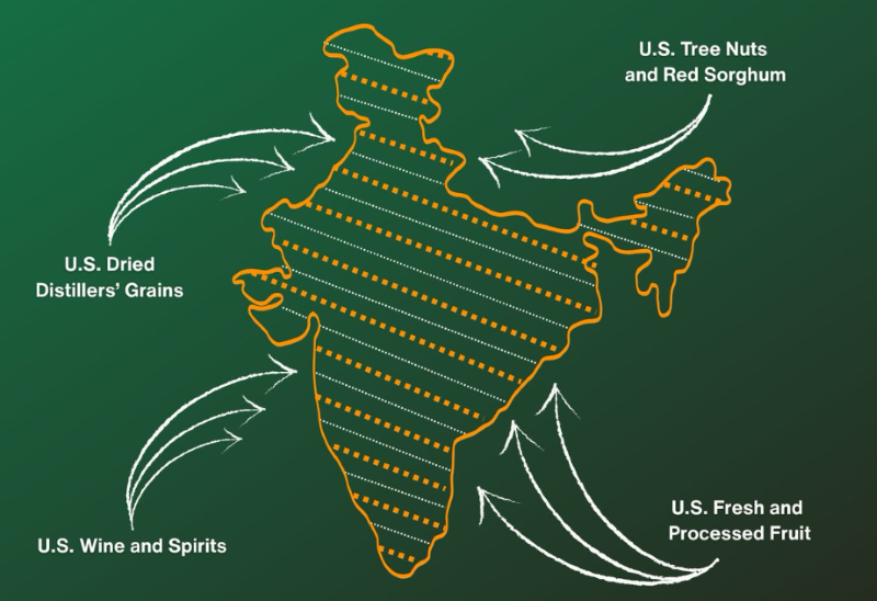
From tree nuts and dried distillers’ grains to red sorghum and fresh and processed fruit, the U.S.-India Agreement will provide new market access for American products. pic.twitter.com/mqpP10LJp1
— United States Trade Representative (@USTradeRep) February 6, 2026
The development comes at a time when Pakistan’s leadership has been seeking closer engagement with the President Donald Trump-led administration. It also coincides with signs of renewed momentum in India-US ties after months of strain triggered by trade tariffs imposed by Washington on New Delhi.
Meanwhile, India and the United States have finalised a framework for an interim trade deal, days after President Trump announced progress on the long-pending agreement. The framework was concluded after nearly a year of negotiations.
Since returning to the office, Trump had taken a firm stance on trade issues with India, citing concerns over alleged unfair trade practices and New Delhi’s purchase of Russian oil.
As part of the new arrangement, the US has reduced the overall 50 percent tariff—comprising 25 percent counter-tariffs and additional duties linked to Russian oil purchases—to 18 percent, offering relief to Indian exporters.
Under the agreement, India has also indicated its intention to purchase $500 billion worth of US energy products, aircraft and aircraft parts, precious metals, technology goods and coking coal over the next five years.
Map triggers social media debate
The map shared on X quickly triggered reactions from both Indian and Pakistani social media users.
One user commented, “The map of India will give severe heartburn to many.”
Another user, Syed Fida Hussain, wrote, “Kashmir’s status doesn’t change because of an incorrect map. Adding Pakistan-administered Kashmiri territories does not mean they are under the control of the Indian government.”
Ajay, another internet user, remarked, “Oh wow! USA has suddenly remembered the actual map of India. That’s miraculous!”
Lakshaya Agarwal posted, “Very appreciative for using the right map of India.”
A Pakistani social media user responded, “Correct your map, it’s not a map of India.”
The post continues to fuel online discussion amid the broader geopolitical context of India-US relations and regional sensitivities.